Dent de Valère et Dent de Valerette
🗺️ Overview
Staring point: Chindonne 1600m, above Monthey
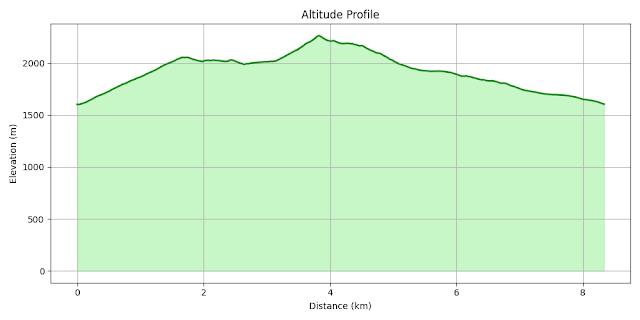
Highest point: 2267 m (Dent de Valère)
Distance: 8 km
Elevation gain/loss: 720 m
Duration: Approx. 3 hours
Difficulty: Moderate; exposed sections on the ridge to Dent de Valère
Highlights:
Panoramic views of the Dent du Midi
Here’s another hike in Valais — probably the most represented category on this blog! After all, Valais is packed with beautiful mountains.
This hike starts in Chindonne at 1600 meters, above Monthey. A small road leads to a hut where you can park your car.
Right next to the hut, the trail immediately climbs steeply through a forest. Around 1900 meters, the trees give way to grassy slopes, as is often the case at this altitude. The final push up to the Dent de Valerette (2058 m) gets steeper, but after about an hour, you'll reach a truly remarkable spot.
Just beyond the ridge, you'll find a modern unguarded bivouac featuring a large panoramic window that looks straight onto the massive wall of the Dent du Midi. The view from here is breathtaking!
This first part of the hike can easily be done as a family outing, with a great spot for a picnic at the bivouac.The second part is more challenging. From Dent de Valerette, you can continue along the ridge towards Dent de Valère. The first stretch is relatively easy, undulating around the 2000-meter mark past the Point de l'Erse.
Once you reach the base of Dent de Valère, the climb becomes steeper and more exposed, with a cliff dropping away on one side. It can feel a little intimidating at times, but the path itself isn't too difficult as long as you stay well away from the edge.
You'll eventually reach the highest point of the hike at 2267 meters.
From the summit, descend the gentler side of the peak. After about 50 meters of descent, the trail curves around the mountain. Several paths crisscross here, all generally leading in the same direction. After crossing the mountain’s edge and descending further, the trail turns into a gravel road that leads you comfortably back to Chindonne.
Overall:The hike covers about 8 kilometers, with 720 meters of elevation gain and loss.
Expect to spend around 3 hours completing the loop.


Comments
Post a Comment